
Scientists have a new solution for counting endangered birds -- using satellite images from space.
A team of researchers from the British Antarctic Survey and the Canterbury Museum in New Zealand showed that high-resolution satellite imagery can see albatross birds from space, according to a paper published in the journal "Ibis" on Thursday.
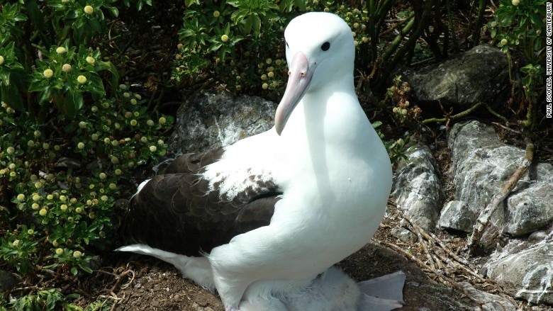
Albatrosses -- large, mostly white seabirds with wingspans of up to 11 feet -- are one of the most threatened groups of birds in the world. They are hard to study, partially because they breed on remote and inaccessible islands.
This is the first time that satellites have been used to count individual birds from space, according to the researchers. Previous studies with other animals have been small and a "proof of concept," whereas this team counted the whole northern royal albatross species in a single breeding season. Counting a species is key to conservation efforts.
The researchers were able to count albatrosses using imagery from the WorldView-3 satellite, which can see objects as small as 30 centimeters. The birds show up as white dots on the satellite images.
"We can see them really well," Peter Fretwell, lead author of Thursday's paper, told CNNTech.
Related: Google Earth gets a mobile-friendly makeover
The researchers know the white dots are albatrosses and not another type of bird because they usually don't breed near other species and typically there are no other large, white birds where they live. While albatrosses could be confused for white rocks in the satellite imagery, this is unlikely as they tend to breed on flat, vegetated areas, Fretwell said.
To test the accuracy of the satellite method, the team counted individual birds on a well-studied colony of wandering albatross on South Georgia, a remote island southeast of Argentina. They found that the satellite-based counts were comparable to previous counts made on the ground.
"We found [satellite imagery] was a really good means of counting," Fretwell said.
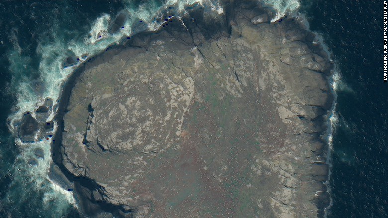
They also applied the method to the northern royal albatross that live on the Chatham Islands, east of mainland New Zealand. Their recent population status was unknown due to the remoteness and limited accessibility of where they live. "One of the colonies was stable, but the other one was much lower than we thought," Fretwell said.
Out of the 22 albatross species recognized by the International Union for Conservation of Nature, 10 are considered endangered or critically endangered. The remaining species are categorized as either vulnerable or near threatened.
Counting birds by traditional methods can be difficult and expensive -- researchers can either count them on the ground manually or charter a plane and take aerial photographs. Both methods also depend on good weather.
"[The satellite] only takes imagery when the weather is fine. We can literally get it almost any time of year," Fretwell said.
Fretwell believes satellite-based methods can now be used routinely to count other large birds, such as flamingos, pelicans, swans and geese. The technology is also starting to be used to see large mammals, such as polar bears and wildebeests.
"This technique will be an invaluable global conservation resource that can give us near real-time information about the status of endangered species," added Paul Scofield, a coauthor of the paper.

