|
Where those driving directions really come from
On the ground with the modern mapmakers who tally, track and measure every road in America.
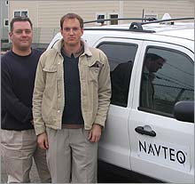
NEW YORK (CNNMoney.com) - Mapquest said it would take 41 minutes for me to drive from Columbus Circle in Manhattan to Far Rockaway in Queens. Google Maps estimated the trip at 39 minutes. I looked at the route and figured it for an hour. About an hour later, I was in Far Rockaway riding around with two of the people who create the raw material for driving directions like those spun out by Mapquest, Google and any number of portable navigation systems.
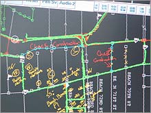
Navteq supplies the raw map data that underlies those directions. That data isn't as raw as you might think, though. Unlike paper maps, Navteq's digital maps have to include details about which roads are one way, which way, and things like whether left turns are illegal Monday through Friday, excluding holidays, from 7:00 a.m to 10:00 a.m. unless you're driving a bus. Users who rely on this data to guide them from one place to another expect an extremely high degree of accuracy. People who use paper maps understand that their map may be old and that the map can't tell them which way they're allowed to go at a given intersection. People using computer programs just expect them to be right. To check those sorts of details, Navteq relies on hundreds of Geographic Analysts like the two men I was with, Senior Geographic Analyst Christopher Arcari and Geographic Analyst I Jean Pierre Loize. They spend about half their time driving around gathering data about every road, large and small, in their designated region of the country. The other half of their time is spent sorting out all that data. If you ever rely on a computer program to get you through Far Rockaway, you owe these men a good deal of thanks because, I'll tell you, there was a lot wrong with Far Rockaway when we got there. For starters, several blocks worth of streets were simply gone. In what is doubtless a welcome sign of improvement for the otherwise blighted section of beachfront we were cruising through, several housing developments were going up. Some were nearly completed and already had new streets with names like Auquatic Place and Beach Breeze Place. Others were just fenced in plots of dirt. Inside the white Ford Escape SUV, Arcari noted the "possible new streets" on an electronic writing pad. As he wrote them, the words appeared overlaying a map on a computer screen attached to the vehicle's dashboard. Inside a locked metal box in the back of the SUV, all the changes were recorded in a laptop computer hooked up to the SUV. The only unusual things visible from the outside of the SUV were a small white cone on top housing a high-powered satellite receiver and magnetic "Navteq" signs on the doors. The signs could be removed to allow the SUV to travel in areas where commercial traffic isn't supposed to go. The missing streets created a problem beyond simply making their current map inaccurate. They also meant that the two main roads through the area were, in a routing sense, cut off from each other. That could create a problem for you, the end user, at some point if you wanted to drive through that area. All streets, you see, are classified by their speed limits and by a number between one and five corresponding to their suitability for long-distance driving. A "5" would be a nice long stretch of interstate. A "1" would be a rutted local road. On the map displayed on the SUV's computer screen, we could see two red roads running along for miles without connecting, then each veered off in its own direction. That was a problem. We had to find an appropriate road to "upgrade," creating a link between those two roads, Rockaway Freeway and Beach Channel Drive. We found a likely candidate in a place where the two roads veered close to one another. Loize drove the Escape through the intersection going one way then another. There were no signs telling us that wasn't legal at any time, so there it was. With a few pokes of his pen, Arcari upgraded the road from a "2" to a "3". It turned red on the map and a new bridge was created. Then we cruised around some more, a trail of green arrows on the computer screen marking our path as we went. A tiny video camera facing out the truck's windshield snapped a wide-angle image every three seconds as we traveled. The resulting images can be used to note street signs and double-check other features. Along the way, Arcari noted road construction that needed to be checked on later. There was a lot of road construction going on. To do this kind of work, Loize explained to me, you have to think like a routing program. Routing programs calculate a path based on speed limits, the suitability of roads and distance. While Navteq supplies the raw data, the calculations are up to the routing company's computer software. They can't always take into account real-world traffic patterns, Arcari explained, which is one reason the results can sometimes seem a little screwy to people who drive the streets every day. It's also one reason my guess about how long it would take to reach Far Rockaway was so much closer than the Web sites' estimates. "There will always be local knowledge," he said. |
| ||||||||||||||||||||||||||||||||||||||||||||