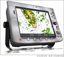
Smooth sailing over troubled waters Rain or shine: One company is revolutionizing the way captains navigate through rough weather. NEW YORK (CNNMoney.com) -- When I was given the assignment to check out Raymarine's latest technology on a yacht in New York harbor, I knew I had done something right. In its latest move, Raymarine, a maker of marine electronics, has teamed up with SIRIUS Satellite Radio to provide detailed weather forecast information to its navigation displays.
That means that for about $1,000, boaters can check out the weather, track storms, and monitor sea surface temperature, wind, surface pressure, wave heights and lightning from the captain's chair. The Marine Weather Service covers the U.S., most of Canada, Mexico and waters extending hundreds of miles into the Atlantic and Pacific Oceans, Gulf of Mexico and Caribbean, but it does require a monthly subscription to receive forecasts onboard, which starts at $29.95 a month. Of course, that's also on top of $4,600 for Raymarine's E Series navigation system with a 12-in. display - not including the cost of individual sensors or installation. But there's a lot more bang for the buck. Boaters can check the weather in a full screen or split screen alongside Raymarine's other features like radar, sonar, electronic charts or global positioning satellite imagery, which provides a picture of the streets, parks and closest happy hour spot near where you plan to dock. There's also a fishfinder function, which shows everything below the surface of the water and a satellite TV receiver. So not only can you track your speed, position, and heading, but you can also watch ESPN or HBO while you zero in on a school of mackerel. Or, if you need more entertainment, you can hook up your Xbox, video iPod or internal video cameras to keep an eye on the engine room or other areas of the boat. Another cool add-on is the automated information system (AIS) which allows boaters to identify and track other AIS fitted-vessels in the surrounding area over a chart or radar screen using digital radio signals. Once detected, AIS will provide additional information like vessel size, name and cargo, which could be useful in preventing collisions or just making friends. |
| |||||||||||||||

